
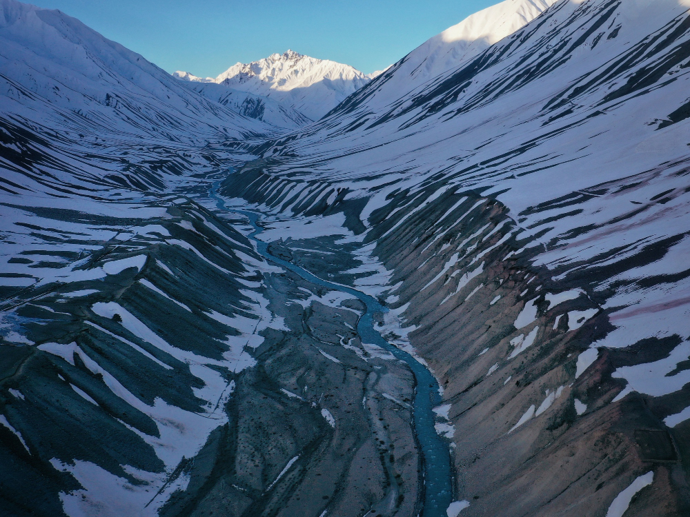
When a farmer awakens in the spring in a remote valley in Gilgit-Baltistan, in Pakistan’s far north, he discovers that his irrigation channel is empty when it was once full. The snowmelt that provided it with food for many generations is either not coming at all or arriving later. The riverbank in a nearby community has changed; the land where families farmed is now downstream, and the water arrived higher and faster than anyone could recall. These are not dramatic occurrences. They are silent, cumulative, and occurring throughout an area with more ice than any other place on Earth save the poles.
From Afghanistan in the west to Myanmar in the east, the 3,500-kilometer Hindu Kush Himalayan mountain range spans eight nations. Ten of the most significant river systems in the world, including the Ganges, the Indus, the Brahmaputra, the Mekong, and the Yellow, are fed by its glaciers. The mountain regions directly supplied by those glaciers are home to an estimated 240 million people. 1.65 billion more people reside downstream. This area is referred to as the “Third Pole” by scientists; this term is not symbolic. The Hindu Kush Himalayas have more freshwater ice than any other place on Earth, second only to the Arctic and Antarctic.
An important peer-reviewed analysis of the state of that ice was published in 2023 by the Kathmandu-based International Centre for Integrated Mountain Development. The startling conclusion was that between 2011 and 2020, Himalayan glaciers vanished 65% more quickly than they had in the preceding ten years. Even researchers who had been observing the area for years found the results concerning, according to lead author Philippus Wester, an environmental scientist.
| Himalayan Glaciers — Key Facts & Data | |
|---|---|
| Region | Hindu Kush Himalaya (HKH) — spanning Afghanistan, Bangladesh, Bhutan, China, India, Myanmar, Nepal, Pakistan |
| Geographic Extent | 3,500 km (2,175 miles) across Central and South Asia |
| Nickname | “Third Pole” — largest concentration of ice outside the Arctic and Antarctic |
| Glacier Melt Acceleration | 65% faster from 2011–2020 compared to the previous decade (ICIMOD, 2023) |
| Ice Thickness Lost Since 1975 | Nearly 27 metres — rate of melting has doubled since 2000 |
| Glaciers Meeting Global Monitoring Standards | Only 7 in the entire region |
| People Dependent on Glacial Water | 240 million in mountain regions; 1.65 billion downstream |
| Major Rivers Fed by HKH Glaciers | Ganges, Indus, Brahmaputra, Yellow, Mekong, Irrawaddy |
| Projected Ice Loss by 2100 (1.5–2°C warming) | 30–50% of volume |
| Projected Ice Loss by 2100 (3°C warming) | Up to 75% in Eastern Himalayas (Nepal, Bhutan) |
| Projected Ice Loss by 2100 (4°C warming) | Up to 80% |
| Key Source Report | ICIMOD HKH Assessment 2023 |
| Glacial Lake Outburst Floods (GLOFs) | Projected nearly threefold increase in risk |
| Shisper Glacier (Pakistan) | Surging since 2017; caused five separate outburst floods |
| Everest’s Glaciers | Lost 2,000 years of ice in the past 30 year |
“As it gets warmer, ice will melt — that was expected,” he replied. However, the speed is unexpected and extremely concerning. This is happening far more quickly than we anticipated. Only seven glaciers in the entire region meet the global monitoring standards that would enable scientists to fully track what’s happening, according to updated data from ICIMOD by 2026, which revealed that glaciers had lost nearly 27 meters of ice thickness since 1975.
The forecasts, which span the entirety of the century, are largely dependent on how well the world controls global warming. By 2100, glaciers throughout the region are predicted to lose between 30 and 50 percent of their volume at 1.5 to 2 degrees Celsius above preindustrial temperatures, the range that the Paris Agreement aims to achieve.
Glaciers in the Eastern Himalayas, including those in Nepal and Bhutan, could lose up to 75% of their mass at 3 degrees Celsius, which is about what current global climate policies are aiming for. That percentage rises to 80% at 4 degrees. These are not speculative worst-case scenarios that are kept in research papers. On any timescale that matters to anyone alive today, these are the most likely outcomes under current trajectories, and they are essentially irreversible.
Before the drought, there is flooding. The majority of glacier melt coverage misses this particular detail. Water scarcity is not the short-term effect of accelerating ice loss; rather, it is an excess of water in the wrong places at the wrong time. Meltwater lakes formed by unstable rock, ice, and moraine are left behind when glaciers thin and retreat.
Since the 1990s, the quantity and size of these glacial lakes have been growing. A glacial lake outburst flood—a wall of water, rock, and debris traveling downvalley at speeds that overwhelm any infrastructure in its path—occurs when their natural dams fail, which happens abruptly and with little warning. In a single year, 16 such floods were recorded in Pakistan alone, compared to five or six in typical prior years. According to one study, the region’s risk of outburst floods will almost triple.
Gilgit-Baltistan’s Shisper Glacier serves as a tangible example of this. In 2017, it started to surge—moving downhill more quickly than usual—blocking a river and forming a new lake. In 2019, 2020, and May 2022, the lake erupted. Homes were destroyed, two power plants were shut down, farms and orchards were destroyed, and a bridge that connected Pakistan and China via the Karakoram Highway was washed away. Because of a monitoring system put in place as part of a UN Development Program project, no lives were lost at that time. However, there was significant damage to the infrastructure, and it is anticipated that the cycle will continue. Additionally, the glacier that started it all is still receding.
The longer-term water crisis is in the opposite direction. It is anticipated that meltwater from glaciers will rise until about the 2050s, after which it will start to decrease as the amount of ice that can be melted decreases. The numbers are especially harsh for the Indus basin, which supplies northwest India and Pakistan; in the upper Indus, glacial and snowmelt contribute up to 72% of river runoff, compared to 20–25% in the Ganges and Brahmaputra. Plans for farmers, cities, and South Asia’s growing hydropower sector are all based on water volumes that might not exist by the middle of the century. In high-altitude areas throughout the region, there are about 650 hydropower projects planned or in progress, many of which are close to glaciers or the lakes they are forming.
There’s a quiet frustration in the numbers as you watch this happen from a distance; it’s not the frustration of surprise because none of this is new science, but rather the frustration of seeing a documented, measured, and predictable process go unchecked. The communities most affected by it—farmers in Gilgit-Baltistan, villages near glacial rivers in Nepal, and towns in Bhutan that rely on hydropower—have made very little contribution to the worldwide emissions causing it.
This was stated clearly in the ICIMOD report: “The people living in these mountains who have contributed next to nothing to global warming are at high risk.” The majority of adaptation is reactive, with communities reacting after a crop failure or flood rather than before. Given the geopolitical complexity of a region comprising eight nations with conflicting interests, it is genuinely unclear whether anticipatory planning at the necessary scale can actually occur. In any event, the ice is not waiting for the policy process to catch up.